Seeking the edge of the world: from Alexander to Columbus
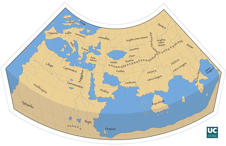
Ptolemy's map of the 2nd century AD
“The regions round the Pillars of Hercules are in connection with the regions round India and between them there is nothing but sea.” This sentence of Aristotle, as preserved by Strabo, inspired the exploration of the world like no other, the only thing that remained to be calculated was how big this ocean was. But let's take things from the beginning.
The peoples of the Mediterranean with developed shipping carried out explorations each one in its region. According to Herodotus, the Phoenicians circumnavigated Africa by order of Pharaoh Necho II, while the Carthaginians made short trips to the Atlantic. But what differentiated the explorations of the ancient Greeks were the sciences.
They had maps with geographical coordinates, they were writting books in which they recorded geographical information and what else they encountered, such as the peoples and their customs, and in this way they prepared the ground for the next explorers. The first map of the world was by Anaximander which depicted a flat earth with the known world of the Greeks around the Mediterranean.
The first great exploration of the world was the expedition of Alexander who, as is known, was a student of Aristotle and was inspired by his ideas. In Alexander's time, India was considered to be the end of the world, so maybe that's why he wanted to conquer it in order to become the master of the world. Alexander and his successors greatly expanded geographical knowledge by providing the information for the last map of antiquity, that of the Alexandrian cartographer Claudius Ptolemy who lived in Alexandria in the 2nd century AD.
During that time maps had evolved. Eratosthenes, the father of geodesy, had invented the spherical shape of the earth, the parallels and meridians, coordinate system while he had measured the diameter of the earth with great precision. But Ptolemy's map had little detail from India onwards, especially regarding China (Sinus as he called it). There was also no end in sight in Asia.
The works of Ancient Greeks had passed in the Middle Ages to Western Europe. A further step was taken in the 13th century when Marco Polo traveled to China through the Silk Road. He further enriched knowledge, named China Katay and Japan Chipango, while for the first time the end of Asia and the beginning of the ocean were shown on maps. But the resulting maps were inaccurate both in terms of the land mass of the Far East and the location of China and Japan. In particular they appeared so far south that they were within the tropical zone.
Another error of the medieval maps is that the diameter of the earth was calculated to be much smaller than it really is and for this they did not believe in the existence of land in between let alone a continent. Eratosthenes' correct estimate of a distance to India of 14,000 miles had been rejected, it was too far anyway for a sea voyage.
In 1453 Constantinople falls to the Ottomans and the Silk Road for Christians is been cut off. The need to cross the Atlantic to continue trade with the east is now imperative.
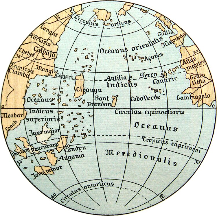
Toscanelli's map shows what lies between Spain and China
Columbus in 1492 traveled according to Paolo Toscanelli's map. The location of China and Japan within the tropics explains the southwesterly course that he followed. Quite coincidentally where he expected to encounter China or Japan he landed to America for this he did not realize that he discovered a new continent.
With the new data Oceania was soon discovered and the first round of the world was made by Magellan in 1519-1522.


